Silting of the PORT GRIMAUD entrance channel :
For several years now, the Port Grimaud entrance channel as well as the mouth of the Giscle have been victims of silting up, which hinders the safe passage of sailing boats...
HISTORY :
There is a current, called the
courant Ligure, which runs along the coast of the Gulf of Saint Tropez, in the direction Sainte Maxime / Saint Tropez.
Numerous groynes were built along the coast to retain the sand carried by the current...
The river "
La Giscle" flowed into the sea with its mouth angled to the right, pushed by the current.
The current of the Giscle is generally very weak. Before urbanisation, wave-induced transport was predominant, creating a continuous sandy strip along the shoreline, blocking the mouth of the Giscle and creating a lagoon behind the sandy strip.
A heavy rainfall was enough to swell the river waters, opening a natural breach in the sandy barrier. The sand transported by the river re-sanded the coastline at the bottom of the Gulf by the Ligurian current and the force of the waves.
the sandpit :
This river sand was sought after for construction purposes, hence its exploitation on the land where the future lake city will be built.
Two sand silos, present on this site, were used as watering holes for the boats. The sand was collected and transported by train or boat to the interior of the country.
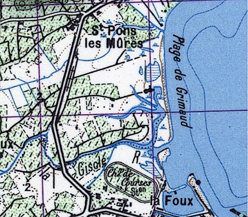
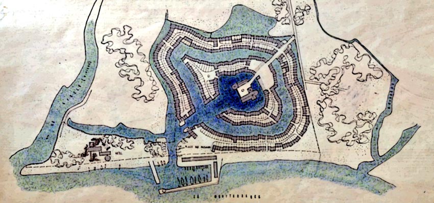
Plan of the mouth of the Giscle dating from before the 2nd World War...
la Giscle :
The Giscle river rises in the Maures massif, in the commune of Collobrières, at an altitude of approximately 650 m, then crosses a large alluvial plain and ends in the Gulf of Saint Tropez. Its length is 15,5 km.
It has many tributaries :
- la Môle (20,5km), the most important, with a slope of 0,5%
- La Grenouille (8,5 km, slope of 4%)
- la Garde (9,5 km, slope of 2,3%)
- la Verne (10 km, slope of 3,9%)
- La Tourré (2,5 km, slope of 4,6%)
- le Gilly (2,8 km, slope of 4,5%).
The entire river has a Mediterranean hydraulic regime with a hot, dry season in summer and heavy rainfall in autumn and winter over short periods of time.
It rains on average 842mm per year. Flows are very low from June to September (0.5m3/s per day). During heavy autumn rains the flow increases to 20m3/s on average. But it can rain between 100 and 200 mm in a single day, i.e. 30 or 40 m3/s. This sometimes leads to major flooding in the plain and therefore to more sediment being carried along and more sand accumulating in the river bed and at the mouth.
As we shall see later, the course of the mouth of La Giscle was profoundly modified during the construction of the lake town and the Marines de Cogolin, which led to a significant silting up of the bed, thus disturbing the navigability of the channel.
Urbanisation has been very important on the banks of the Giscle in Cogolin, La Môle and Grimaud, generating the disappearance of natural or agricultural areas which have influenced the hydraulic functioning of the waterways.
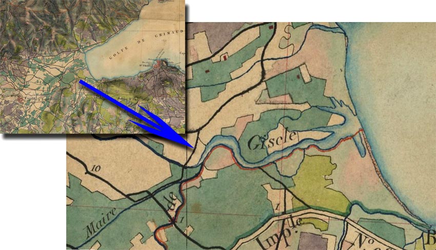
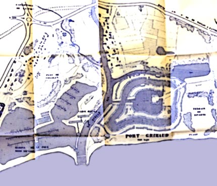
The mouth of the Giscle on the State Major Map of the late 19th century.
Development of the GISCLE :
Since the 1960s, the banks of the Giscle and its tributaries have undergone numerous developments that are not always natural :
1 - STABILISATION of the riverbed
- by
CUTTING IN either in the river bed or on the banks, sometimes with the addition of concrete for better consolidation.
- by
VEGETABLE TECHNIQUES using natural materials :
+ The
fascines (barrier of dead wood piles),
+ cuttings of various plants to promote plant recovery,
+ coco nets (made from coconut husks, which are biodegradable and therefore less durable than riprap),
- by the creation of
QUAIS in Port Cogolin, Les Marines de Cogolin, the shipyards, the "Riviéra" campsite and Port Grimaud.
2 - IMPROVEMENT of flows
- by cleaning, restoration or dredging.
The canes of Provence form cane trees that can be found along the bed of the Giscle and its tributaries. They retain the soil and thus limit bank erosion. However, care must be taken to ensure that they do not overflow into the river bed as they would impede the flow of water. They must therefore be cut regularly.
It is also necessary to clear the bed and the banks, to eliminate dead wood and objects of all kinds (sometimes abandoned by unscrupulous people) which settle on the bottom of the river, hindering the flow of water.
3 - Creation of DIGES, drainage ditches
but also
dams and landfill channels on agricultural land.
4 - Development of BRIDGES and footbridges
These structures were intended for overland passage in connection with the growing urbanisation of the region.
They have a very strong influence on water flow
hydraulic functioning of watercourses
The evolution of land use and urbanisation has modified the hydraulic functioning of the watercourses.
Namely:
- Urbanised soil runs off more than natural soil and agricultural soil.
- Agricultural soil runs off more than natural soil.
The agricultural soils bordering the Giscle and its tributaries are particularly sensitive to erosion. During heavy rainfall, the phenomena of runoff and soil leaching are accentuated, which contributes to increasing silting and aggravates the phenomena of flooding.
Moreover, after the numerous fires that destroyed the vegetation cover on the surrounding hills, these heavy rains ravaged and carried with them, as they flowed down to the plain, numerous sediments that contributed to the silting up of the river beds and the mouth of the Giscle.
types of flooding
-
Flooding due to torrential flooding :
These flash floods are due to very heavy thunderstorms with limited localization, and leading to a very rapid rise of water in rivers with a steep slope and narrow bed. This is the case of the Garde and the Grenouille stream. Materials, such as dead wood, are transported, which further encourages major flooding.
-
Flooding due to runoff :
They arrive in very heavy rainfall in urban areas, where water cannot easily infiltrate into the ground.
-
Flooding of the plains crossed by the Mole and the Giscle :
After several days of continuous rain, the riverbeds overflow.
Failure of the Môle dam :
Here is a map of flooding in the event of a breach of the Môle dam :
This earthen dam was built in 1991 creating an artificial lake of 8 million cubic metres which supplies drinking water to 10 communes in the Gulf of St Tropez.
Its water is treated by the Verne water treatment plant and managed by the Syndicat Intercommunal de Distribution d'Eau de la Corniche Des Maures.
This dam is fortunately
highly guarded and of
daily maintenance. It is
very safe and this map is for information only...
The floods of the Giscle :
- January 1959 : Exceptional flooding.
- 11 and 12 january 1996 : The ten-year flood caused the flooding of a large part of the Giscle plain for more than 2 days.
- 14 July 2002 : Very localized 100-year flood in the upper Giscle basin.
- 13 and 16 December 2008 : Upper flood of the Môle, the most important tributary of the Giscle.
- from 14 to 20 September 2009 : Strong flooding of the Giscle with overflow in the Pommiers district.
- from 21 to 23 October 2009 : Very high flooding of the Giscle with flooding at Pommiers, Camp Marin, and the Grimaud artisanal zone.
- 15 and 16 June 2010 : Heavy flooding of the Giscle.
- from 3 to 9 November 2011 : The equivalent of 7 months of rain in 5 days in the Giscle catchment area. Flooding of the Grimaud plain.
- 14 December 2012 : Flooding of the Môle.
- 7 and 8 March 2013 : Flooding of the Môle and Giscle rivers with flooding of the Grimaud plain.
- 26 and 27 November 2014 : November was an exceptionally rainy month. Overflowing of the Môle and Giscle rivers with flooding, during the night of the 27th, of the Pommiers district, the Grand Pont business park, Saint-Pons and the PG1 car park.
- from 18 to 23 November 2019 : A week of continuous heavy rainfall, unprecedented over such a long period, and overflowing of the Giscle at Les Pommiers, Camp Marin and the Grimaud industrial zone.
- 1st December 2019 : Very heavy rainfall throughout the day and overflowing of the Giscle at Les Pommiers, Camp Marin and the Grimaud industrial zone.
- 9 and 10 March 2024 : Very heavy rainfall overnight on Saturday and Sunday, with the Giscle overflowing its banks at Les Pommiers, Camp Marin and the Grimaud industrial estate.
Municipal information document on MAJOR risks :
"
This document allows you to know the different situations to which our commune is exposed, as well as the measures taken to limit the consequences on the population."
Alain BENEDETTO
Aerial views
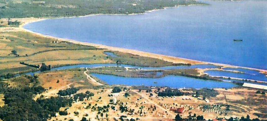
Aerial view of the mouth of the Giscle before the beginning of the construction of the Marinas tended to go to the right, in the direction of the Ligurian current.
Aerial view in 1967. The Giscle was practically closed.
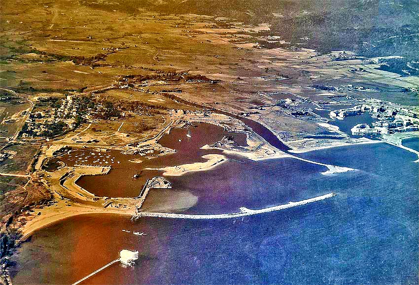
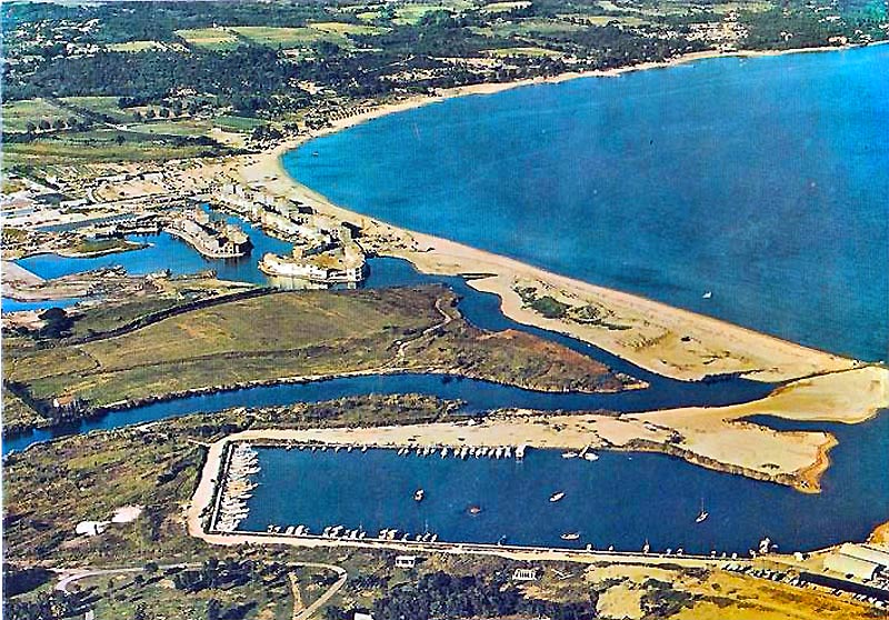
Aerial view in 1969. The Marines de Cogolin were emerging from the ground. The Giscle River was flowing through a small passage.
The spur on the Port Grimaud side was not built when the Marines' spur was not yet curved.
The Giscle could flow normally...
Sketch from 1963 with an exit to the sea: the Giscle had its normal curvature.
Sketch from 1965 with an exit to the sea: the Giscle had its normal curvature.
Project of 1964 with exit on the Giscle: the mouth is vertical.
Project of 1965 with exit on the Giscle.
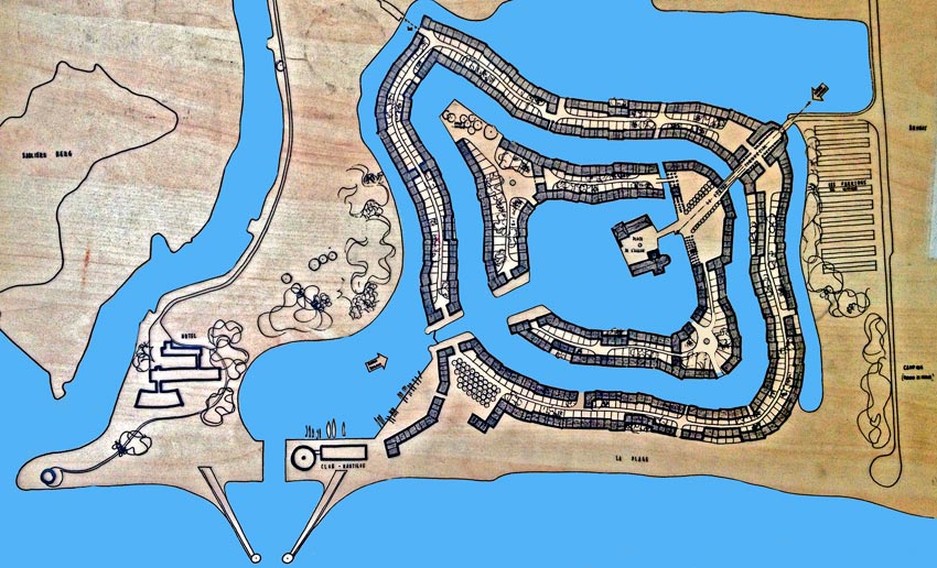
Construction of Port Grimaud :
from 1966
Construction of the Marines de Cogolin :
from 1968 to 1980.
Construction of Port Cogolin :
1982
Construction of piers :
Work began in 1966 at PORT GRIMAUD. For a long time, the architect hesitated, as we have seen: sometimes the exit was on the Giscle, sometimes on the sea... After a strong flood of the Giscle which flooded the nascent construction site of the lakeside city, the choice was definitively made for the sea.
Between December 1966 and February 1968, while the architect was working on what was to become his lake city,
the beach receded by 20 to 25 metres!!!
François SPOERRY decided, on the advice of the Ponts et Chaussées engineers of the time, to build a jetty that would neutralise the action of the wind and sea and hold back the sand...
The work was entrusted to the SPADA team of specialists from Nice led by Maurice CARUSO, and began on 15 March 1968.
The first step was an experimental spur that would serve as the base for the future pier. It was straight :
The first experimental spike.
Opened at the beginning of the summer of 1968 for the pleasure of the first owners and summer visitors, the channel was closed from mid-October 1968 to the spring of 1969 in order to extend the pier with a curved breakwater.
Once this single groin was completed, the shoreline was fully stabilised and the beach on its northern side (PG1 beach) was seen to be growing.
The sand carried by the Giscle was deposited on (and in front of) the beach of PG2.
Work on the Marines de Cogolin began in 1968, when a triangle-shaped pier was created.
The depth of the Port Grimaud entrance channel was originally about 5m. That of the Giscle was
3m.
Then came the gradual silting up...
PIEGE à SABLE
A letter from an engineer of the Ponts et Chaussées de Toulon in charge of the Giscle file, dated 20 January 1975, explains that the orientation of the dikes favoured the creation of a sand trap in front of the small beach of PG2.
The sandpit on the Giscle :
For many years, on the Giscle, a sand pit was in activity behind the Renault garage on the Cogolin side and, thanks to it, there was no talk of silting...
It closed down about 15 years ago, probably because of the new sand extraction regulations...
Hence the question: Could a new sand pit at this location address much of the silting?
National Center for Ocean Exploitation :
This centre published a very interesting report on "RESEARCH IN SEDIMENTOLOGY APPLIED TO THE ROCKY LITTORAL OF PROVENCE ".
In this report, there are 2 drawings showing, by arrows, the flow of the waters of the Giscle, the "jetties" of the Marines and that of Port Grimaud do not interfere with this flow which goes offshore...
In this report, it is stated that: "
the course of the Giscle has moved southwards, under the influence of a littoral transfer along the coastline to the NE. of the Bay of St Tropez. This sedimentary input was increased by the load of the Préconil and directed from East/North-East to West/South-West.
By moving southwards, the Giscle has left behind three inlets, lined with ponds and marshes, destroyed by the development of the Port Grimaud Marina. "
DRAGGING :
The sediments, mainly composed of sand, accumulating at the bottom of the river, hinder navigability, hence the obligation to dredge the river bed.
This sand is recovered to replenish the beaches.
The first recorded dredging took place in 1995 between the RN98 bridge and the mouth, reducing the depth of the Giscle to 2.5m. 12 650m3 were thus taken.
Port Grimaud2, in charge of the maintenance of the river in 2000, carried out 2 dredgings in 2002 and 2003.
PG2’s ASl carries out 2 bathymetries per year to monitor the depth under the boats.
The legislation on dredging was less rigorous than today and the silting up was less important than today.
November 2011 :
This month of November was marked by heavy rainfall, which caused the creation of the sandbank, deposited in front of the PG2 beach, between the mouth of the Giscle and the entrance channel of Port Grimaud.
During the Port Council meeting held on 20 December 2011, alerted by a member of this council, the Commune of Grimaud became aware of the problem and hastened to proceed with the emergency lighting of the dangerous zone.
Since 2011, perhaps because of global warming, violent floods have followed one another, each time moving a significant volume of sand that has come to "enrich" the sandbank until it reaches a volume of
30 000 m3 approximately, constituting an obstacle to navigation in this area located
outside the conceded port perimeter.
REMARKS :
The most important silting is located on the Domaine Publique Maritime (DPM). Only the "administration" should normally intervene.
On the other hand, the 2 entrances, Giscle and Plan d'eau de Port Grimaud are part of the concession and are the responsibility of
PG1,
PG2 and the
SNPG of PG3. They must ensure their desilting and safe access.
These 3 entities have collectively participated in the costs of dredging concerning this area for several years while by a
notarial act of 4 January 1973 constituting "easements between the three entities", it is written on pages 11, 12 and 15, that PG1 grants to PG2 and SNPG "
an easement of passage and free circulation across the sea outlet", that "
This easement shall confer upon any owner of the dominant lands the right to pass and circulate freely by boat or other navigational craft across the sea outlet" and under the heading "
distribution of charges", "
In respect of the bodies of’ water bodies, canals and the river La Giscle, each of the servient funds shall maintain, dredge and mark them at its own expense"...
Therefore, PG1 had to bear the costs of dredging the entrance channel alone (outside the DPM) and the costs of dredging the Giscle had to be borne by PG2...
This decision was taken by the architect at that time because the silting up was low, PG2 was emerging while PG1 was already receiving revenues from visitor parking and mooring rentals.
PG2 did not appreciate at all, having undertaken to share the costs, that PG1 used somewhat authoritarian methods, deciding alone on the conditions of the dredging, the choice of the company, the acceptance of the estimate for the work without consulting the other entities, contenting itself with sending the invoice for the work carried out without any other comments with a cost of the m3 of sand removed at
75€ whereas in 2017, the municipality invoiced for this same m3 at
25€ !...
With the agreement of PG2's owners, the President of PG2 refused to participate in the extraction costs, which led to a logical conflict with PG1, which held its ground.
September 10, 2019
Faced with PG2's legitimate refusal to contribute financially to the dredging of the entrance to the pass, PG1's ASP took the case to court: on September 10, 2019, a ruling by the Draguignan Regional Court dismissed PG1's claim, which was appealed.
PG2 has nevertheless set aside the sums claimed pending the Court of Appeal's ruling.
REFUND :
The sums claimed by PG1 for participation in the costs of dredging the entrance channel were provided for up to 50% of their amount, 121,079 €uros, on 31 December 2023..
At the last general meeting of Port Grimaud2, held on 1 April 2024, the president of this entity, who for the past 2 or 3 years has also been the union councillor for PG1, asked the residents present to ratify a memorandum of understanding that would put a definitive end to the proceedings that have pitted Port Grimaud1 and Port Grimaud2 against each other for the past 9 years, in return for payment by Port Grimaud2 of the sum of 100,000 euros in full and final settlement.
At no time did he mention the notarial deed dated 4 January 1973, or the comments made in his letter of 14 January 2012.
Strangely, the residents have agreed to ratify this protocol without waiting for the outcome of the current appeal....
The
ASP of PG1, on 20 January 2016, and the
ASL of PG2, on 23 March 2016, carried out bathymetric surveys which revealed particularly dangerous conditions of access to the entrance channel of the Giscle in its part situated on the
Domaine Public Maritime (DPM); Access to the entrance channel of the Giscle in its part situated on the
Domaine Public Maritime (DPM), particularly dangerous, with sand outcropping over more than half the width of the mouth. Boats could no longer pass each other at this point without risking running aground on the sandbank.
An initial safety dredging of
2 700 m3, in the entrance channel on the Giscle side, in the area located on the Public Maritime Domain took place from 27 June to 22 July 2016 and made it possible to re-establish safe access to the Giscle entrance channel. This work was carried out by the
AZOTE company under the direction of
ASP1 which had undertaken the dredging of the conceded entrance channel at the same time.
The costs incurred by the PG1 ASP for this summary dredging operation on the unconcessioned part amounted to
93 636 € TTC. The Town Hall reimbursed them for this sum.
Then, at the beginning of 2017, in the absence of an agreement between the port concessionaires and the Commune, notably on the issues of taking charge of the dredging work and its financial distribution, the Commune proceeded to extract approximately 15,550 m3 of sand. The sand extracted from this dredging operation was used to refill the municipal beaches with sand.
Sometimes, the floods of the Giscle, when they are not combined with a strong sea pushed by a violent east wind, are beneficial for the desilting because they "clean" the bed of the river, chasing the deposited sand out to sea...
TO BE MEDITATED :
PORT GRIMAUD is not alone in suffering the silting up of the Giscle:
The river is bordered by many owners, some of whom use it regularly:
- Les Marines de Cogolin with numerous moorings and a launching area.
- Port Cogolin, which can only be reached by the Giscle, and has many moorings on the 'gisclet
- The shipyards 'Villanova', 'Team Boat Service', 'Simons', 'OMV'
- The campsite 'Holiday Marina' with a long linear layout.
- The Hotel 'Le Ginestel'
The other riparians are often private individuals. Numerous agricultural lands also border the Giscle, bringing numerous alluvial deposits by runoff during the rains... Some of the land is municipal.
It should be logical that ALL these residents should contribute to the cost of clearing the land !
SE.D.RI.PORT :
'
SE.D.RI.PORT', (Sedimenti, dragaggi, rischi portuali), is a European project initiated by the Region of Sardinia in partnership with the Department of VAR, the Universities of Cagliari and Toulon, the Province of Livorno, ARPAL Liguria and with the objective of finding a common solution to the problem of silting up ports.
In 2018, the commune of GRIMAUD, as part of this project, launched
a call for tender for a "hydrosedimentary modelling of the area before Port Grimaud".
The company "
CORINTHE Ingénierie" won the contract.
In its final report, the company proposed 2 solutions:
- 1st SOLUTION: Remove the bend in the Marines decogolin dam
- 2nd SOLUTION: Modify the protective dikes at the entrance to Port Grimaud.
These 2 solutions, unfortunately, did not address the silting problem in its entirety, hence
the proposed solution :
AUDIT of the MAIRIE :
Port Concessions Audit and Expertise 2019 published on 11 December 2020.
This audit shows me that :
- There is no visible mess on the sheet piling
- Sheet pile thickness greater than 2.5 mm
- The operation of the cathodic protection system is normal
- There are no serious disorders on the surface docks
- There are no serious disorders on the submerged structures.
It also notes that
the cost observed for a space appears to be much lower than the market price and defines a target balance between co-ownerships and the commune on the following points :
- The historical advantage is to be reconsidered
- The Commune must draw resources from its assets
- The Commune is an actor in the development of its territory
- However, the value and attractiveness of private land will remain linked to the attached berths.
It concludes that the main items of capital expenditure from 2025 onwards will be :
- The development of the entrance channel to reduce silting and pacify the water, and thus exploit the new space created by the creation of 45 additional public moorings. Estimated cost :
7,4 M€(valeur 2019).
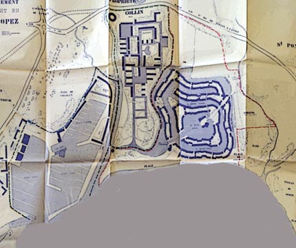
It takes up the CORINTHE Ingénierie study with the following plan :
We discover :
- 14 moorings of 10x3,70m
- 12 moorings of 12x4,20m
- 5 moorings of 15x5m
- 4 moorings of 21x6m
- 6 moorings of 25x6m
- 4 moorings of 30x8m.
At today's prices, these moorings could bring in around 93,000 euros per year.
-
Doubling of existing sheet piling with PVC sheet piling (and filling the space with concrete). Cost : 4500 euros de ml., either for the entire length of the quay :
58,5 M€ HT distributed
as follows :
- PGI to be carried out between 2025 and 2030: 6 km of quay for a total of 27 M€ HT ;
- PGII to be carried out between 2030 and 2035: 4km of quay for a total of 18 M€ HT ;
- PGIII to be built between 2030 and 2040: 3km of quay for a total of 13,5 M€ HT.
Everything will be decided during the negotiations between the co-owners and the town hall...
Dredge 2024
Since the local authority took over the waterway, it has been its responsibility to dredge the entrance channel to ensure that it remains navigable and safe for pleasure craft. This has been done every winter since 2022, and again in February 2024.
,600 cubic metres of sediment were removed, at a cost of €755,000 excluding tax. This cost could have made it possible to remove 15% more sediment if the PG1 ASP had agreed that the sand removed could be stored temporarily on the PG1 beach, as was done when this entity was responsible for dredging the channel. However, the ASP refused to cooperate with the Régie, despite the fact that this necessary dredging primarily concerned the residents of the lakeside town.
In this war between the PG1 ASP and the commune, the Régie explains that, having informed PG1 of the start of the dredging operation on 21 January, the co-ownership would have planted oleanders in the middle of winter, outside the usual planting period for the species, in the path of the mechanical equipment, to prevent them from passing !
Port management by the Régie :
Since 1 January 2022, the concessions have been terminated and management of the port has been taken over by the local authority, thus avoiding the need for a tender process that could have resulted in highly commercial management by a private company.
The municipality has commissioned a feasibility study to determine the work required to secure the port and bring it up to environmental standards. Several companies have been selected.
This study has highlighted several technical and environmental problems related to the ageing infrastructure and the lack of compliance of the structures with nautical regulations. This has led to the identification of five areas of work to be considered, including :
1 - Securing the entrance pass :
The current sea walls do not protect the lake and do not prevent sediment from the Giscle River from entering, causing the entrance channel to silt up. Hence the need to rebuild the sea walls.
2 - Dredging of the entrance channel and canals :
Some PG1 channels are particularly silted up and muddy, with the presence of polluting macro-waste. It is therefore necessary to bring them up to standard with a multi-year plan to dredge the entrance channel and clean out the channels, with, if possible, the recovery of sediments.
Works subject to public inquiry :
The following is planned:
- Dredging of the entrance channel to restore it to its original dimensions and achieve a depth of 5 metres in the middle of the channel, requiring the removal of 30,000 cubic metres of sediment.
- Redevelopment of the outer harbour and the exit from the breakwater, including:
- Raising and extending the sea wall to the south
- Raising and extending the embankment to the north (towards the harbour master's office)
- Extension of the south quay to limit silting of the PG2 beach
- Rectification and extension of the Giscle estuary.